
Start Planning Your 2026 River Trips on NationalRiversProject.com
posted by
Discover new rivers and accesses for paddling and fishing with this free database
By Bekah Price, River Management Society
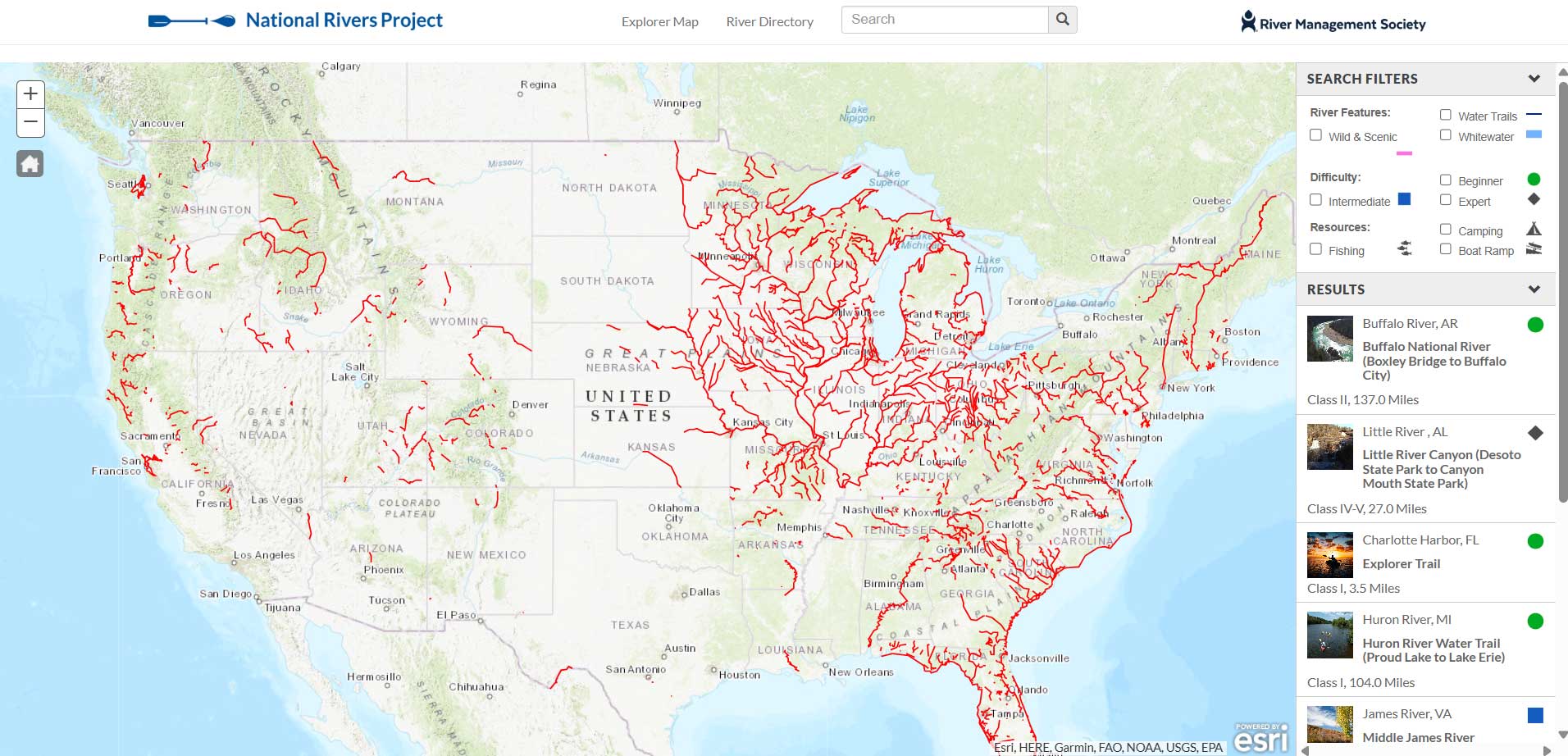
There are thousands of boatable rivers in the United States, but finding the right trip for you hasn’t always been easy. Unlike hiking trails or road trips, paddlers and anglers haven’t had a reliable way to “shop” river reaches by experience and often don’t know who manages their rivers. To solve this, the River Management Society created the National Rivers Project, a searchable database of recreational river reaches, mapped from put-ins to take-outs.
“We wanted to make it easy for people to discover new rivers and to get information directly from their local river managers,” says James Major, National Rivers Project Coordinator with the River Management Society. “Now, you can start with the experience you want and quickly find the reaches that fit.”
Developed in partnership with dozens of state, federal, and local agencies, the National Rivers Project website is a free and growing database of thousands of boatable river reaches and access points across the United States.
“Making accurate river trip information accessible takes coordination with many partners,” says NRP data partner Heather Barrar, Regional Trails Program Director at Friends of the Lower Appomattox River. “What makes this resource so valuable is that river managers are contributing the data directly. We’re excited that it features our river and access sites because it helps more people discover them and connect back to our organization and the work we’re doing.”
Each year, it helps tens of thousands of paddlers and anglers plan trips based on geography, difficulty, and recreational opportunities, while also serving as a hub for water trails, wild and scenic rivers, and whitewater runs.
“As both a paddler and a researcher studying river access, I've turned to the National Rivers Project for over five years,” says Ben Fowler, CEO of PARKS360 and Clemson Ph.D. Candidate. “Lack of reliable access information keeps countless potential river users off the water, and this database tackles that problem head-on with data sourced directly from river managers. It's a one-of-a-kind resource the paddling community should use far more widely.”
While search engines and social feeds tend to funnel people toward already crowded destinations, the National Rivers Project opens the door to those “rivers less paddled.” Whether you’re looking for a mellow float, a new fishing spot, or a whitewater run, the database makes it easy to branch out while reducing congestion at hotspots.
The site is easy to search and navigate, with filters on the interactive map and a state-by-state directory. River difficulty is color-coded like ski routes, and users can filter for amenities like campsites, fishing access, and boat ramps.
Each river reach has its own page with data provided by river managers, along with links back to their websites for more detailed, local information. Explore the database and start planning your next river trip at https://www.nationalriversproject.com.
The National Rivers Project is managed by the River Management Society, a nonprofit organization that supports the professionals that study, protect, and manage North America’s rivers.